TREKKING IN AMALFI COAST
Itineraries from Ravello
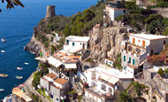
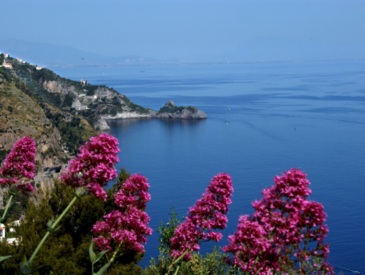
Walking around Ravello
This
publication should be of assistance to those who wish to discover the area
of the coast surrounding Ravello, and walk along the pathways and up and
down those steps which, until the last century, were the only roads linking
the slopes on which Ravello and Scala stand with the sea. Hence the most
significant routes are indicated; those which wander through terraced lemon
groves and open onto unexpected views and groups of houses where time seems
to have stopped and churches and monuments which stand as witnesses to the
grandeur of this area so steeped in history.
A breathtaking experience is guaranteed.
RAVELLO - ATRANI - VIA VALLE DEL DRAGONE
This itinerary is considered a classic, as it was the route used by the local people before the paved road was built in 1930. From Piazza Duomo take Via Roma as far as the recently restored 11th century church of Santa Maria a Gradillo (venue for the workshop of the Mediterranean Forum in 1996) turn left immediately after it and take the few steps down to the road. Cross the road and you will find a flight of steps with a signpost To Amalfi. Here the descent to Atrani a begins. After about 5 minutes walk you come to the paved road once again. Crossing over to the other side and proceeding along the road for about 500 meters you will another signpost for Amalfi and a flights of steps. Passing through a small portico under a building, follow the paved road down to the Ravello Pontone crossroads. There you turn tight and after the first curve you come to a small cross-way sign To Amalfi. Continuing along this path you pass the ruins of a small village with its textile and olive oil mills. This valley, called Valle dl Dragone, was in fact the industrial area of Atrani. Towards the end of the path, before entering the town of Atrani itself, you can see the towns old cemetery, which was used until the end of 1800s, and the adjacent Chiesa del Carmine. pAssing the church, any path you take leads down to Piazza Umebrto I in Atrani town. Among places of interest, in the square there is the small church of San Salvatore deBirecto, where the proclamation of the DEGES took place during the time of the Maritime Republic of Amalfi. To avoid the heavy traffic of the road from Atrani to Amalfi there is an alternative route. Starting from the main square looking at the church, take either of the two stairways on your left and keep left.
RAVELLO - ATRANI THROUGH CASTIGLIONE
Starting from Piazza Duomo take Via Trinità to the right of Villa Rufolo and follow the directions for Villa Cimbrone. At roughly 10 minutes walking distance, take the stairway to the rights down Via Santa Barbara. Keeping to the left along this route and looking across the valley you can enjoy the view across the Valle del Dragone to Pontone and Torre dello Zirro, a watchtower where the Duchess of Aragona was imprisoned. About ten minutes walk up Via Santa Barbara you turn right and, following the indications to Amalfi, the paved road brings you out near a limoncello distillery. Cross the road here and follow the signs to Atrani. The steps will take through the Castiglione area and past the place from which M.C. Escher painted the bell tower of the church of Santa Maria Maddalena, in Atrani.
RAVELLO AMALFI WITH DETOURS TO THE TORRE DELLO ZIRRO AND TO THE VALLE DELLE FERRIERE
The first
part of this itinerary is the same as the Ravello Atrani Amalfi one as
far as the portico. At this point turn right and go up the paved road until
you reach the main square of Pontone. Here, leaving the entrance of the
church of San Giovanni behind you, take the steps will of Via Fritto.
Proceed for about 10 minutes along this road and you will come to another
flight of steps leading to Amalfi. This itinerary offers the choice of two
very interesting escursions. One leads to the Torre dello Zirro, which is
one of the oldest watch towers on the Amalfi Coast, strategically situated
above the town of Amalfi, now a nature reserve where a rare species of fern,
known as the woodwardia radicans, can be found.
To reach the Torre dello
Zirro, once at the small square of Pontone take the path way left of
the paved road and
follow the indications for the tower. You pass the small church of Santa
Maria del Carmine and begin climbing a series of steps which mark the
beginning of the
trail leading through the
characteristic Mediterranean vegetation of the woods.
Alternatively in order
to visit the Valle delle Ferriere you take the pathway passing out of
Pontone to the right which leads to the end of the Valley (approx. 2 km).
This trail leads to the rive in the proximity of an antique iron works of
an antique irons works, which gave its name to the valley Le Ferriere.
From here the walk to Amalfi passes the old paper mills where the famous
hand-made paper was produced. Once in the town you can visit Paper Museum.
The Ferriere Valley Nature
Reserve, instituted in 1972, in the Scala local council territory behind
Ravello, constitutes the only protected area on the whole Amalfi coast. The
Reserve protects a steep valley of the Lattari mountains and allows you to
discover the impervious face of a region more commonly celebrated for its
spectacular coastal aspects.
The Lattari mountains, whose name derives from the breeding of milking cows
that is traditionally undertaken here, in several points rise higher than
1000 metres. This place is blessed regarding the availability of water,
which in the past favoured the growth of ironworks, factories and,
especially, the famous Amalfi paper mills. The same abundance of water
allows the presence of some rather unusual plant species. In particular, the
Reserve boasts the ownership of the very precious Woodwardia radicans, a
rare example of pre-glacial flora.
RAVELLO - MINORI
This
itinerary begins from Piazza Duomo, heading towards Villa Rufolo. On the
left of the entrance gates you ll find Via Annunziata, which is the first
flight of the steps you want to take. On your right you will see the church
of the Annunziata, one of Ravellos major churches, which today is used us a
conference hall. Once past the church you come to a paved road. Crossing
this you will find the second flight of steps which leads to the area of
Torrello. A three minutes walk will take you to the church founded of San
Pietro alla Costa. It dates back to the 10th century but has been
rebuilt many times since and ultimately restored in the 1970s. On the way
down towards the square in Torello there is a choice of two routes to Minori.
You can take the wide
steps of Via Santa Croce to the left, which pass under a pergola of vines
and lemon trees and lead past the ruins of the church of Santa Croce and the
cluster of buildings of Villamena with its 10th century church of
San Gennaro. Alternatively, going straight, the path of leads to the square
in Torello where there is the 10th century church of San Michele
Arcangelo. Following on down the steps, towards Minori and keeping right at
the crossroads with the chapel, you will leave behind you a characteristic
view of Ravello.
FROM RAVELLO TO MINORI VIA VALLE RHEGINNA MINOR
Leaving Piazza Duomo and taking the flight of steps up Villa Wagner you will come to the Principessa of Piemonte, the panoramic terrace situated between hotel Palumbo and Palazzo Sasso. Further along via Toro is Piazza San Giovanni del Toro, a small square which takes its name from the adjacent 11th century church. Proceeding from here along Via Margherita past the ruins of a church dedicated to the same saint and quaint courtyard of the Hotel Parsifal, once the convent of SantAgostino you reach Piazza Fontana with its Moorish Fountain. Keeping on walk on same direction youll reach another square. Here stands the church of Santa Maria del Lacco and the two bestions that were part of the entrance gates to the city of Ravello. Leaving the church on the right, go along the wide stairway past the church of San Martino returning for a few yards in the direction of Ravello before deviating left towards the Sambuco area. This leads you passed the ruins of Santa Maria della Pomice, after which a right turning marks the beginning of the trail which leads along the Reghinna Minor torrent into Minori. The route winding through the wooded landscape passes the old paper mills and other factories which utlized the water power from the river.
RAVELLO - SCALA - MINUTA - PONTONE - RAVELLO
For the first part of this itinerary refer to previous itinerary as far as Piazza Fontana. From here there is a stairways to the left that leads down to the road you will arrive at the town of Scala. Keeping to the right and following the road you will arrive at the town of Scala. Pass the main square of Scala and the church of San Lorenzo and proceed to approximately ten minutes toward the area of Minuta. Here, following the signs, you will begin the descent towards the area of Pontone, passing the 11th century church of the Santissima Annunziata and the suggestive ruins of SantEustachio. Continuing for about 10 minutes, you arrive at the village of Pontone, from where you can return to Ravello by retracing you steps, from the first part of the third itinerary or, alternatively, you can proceed down towards Amalfi.
Itineraries from Positano
- From Arienzo place you go up by 1834 steps at Nocelle (420 metres) and from here to Montepertuso, by Fontana Vecchia to Valle Pozzo, in order to reach St. Maria del Castello (685 metres). Time taken 3 hours.
- From Liparlati street you go up through Grado street at Montepertuso. Time taken 1 hour.
- From Corvo place, through St. Giuseppe district you go up at St. Maria del Castello. Time taken 1 hour and 30 minutes.
- From Montepertuso cross-roads you go up towards Capo d'Acqua and Croce, joining Lattari street, and trekking high over the Sorrentino-Amalfitana Peninsula. Time taken 2 hours.
Itineraries from Amalfi
Parks, woods, and replanted territories
Pogerola Mount;of municipal property, extended for 1,50 hectars; composed of
conifers and broad-leaved, with access from municipal street to the Castle.
Cappuccini wood in Tabor place, extended for 2 ectars, composed of broad-leaved, in
ilex prevalence, with access to Cappuccini Hotel.
These woods present a typical mediterranean vegetation, also with mirth and arbutus. As
far as fauna is concerned, it is assumed that among the others there are blackbird and
Italian fox.
Pogerola Mount; re-forestation of black and Aleppo pines made during years 1955-60.
All the territory of the Amalfi Coast is inserted in "Parco di monti Lattari"
(LattariMounts Park).
Fauna
Blue rock thrush (protected species); it builds its nest in rock ravines and in abandoned ruins exposed toward south. Rare hawk (protected species); it also builds its nest in rock ravines and in abandoned ruins exposed toward south. Royal owl (protected species); generally prefers caves for nest-building and it is found also at low altitude; Spotted little salamander, placed in micro-enviroument with high moisture rate, such us around ruins of old farm houses.
Water courses
- Canneto Stream It originates at "lama dei gatti" place in Scala town, crosses the natural reserve of Forges Valley, and joins into Amalfi territory, runs through Grevone valley river-bed, marking natural borders between Scala and Amalfi towns. It flows into Amalfi big Marina.
- Leaving from Amalfi - St. Basilio you arrive at Pogerola hamlet, to cross Riulo place up to Tavernate plateau (time taken 2 hours).
- It always begins from Cartiere street, crosses Grotte street, and leads to Pontone hamlet in Scala town (time taken 1 hour).
- Amalfi - Orientated natural reserve. From Comunal Paper-mills street you skirt Grevone valley, in which Canneto river runs, up to arrive to Mills valley and to ancient forges ruins, in homonymous valley (the access to reserve is however authorized on request to ex firm of Stato Foreste Demaniali -Public Forests State); time taken 2 hours.
Itineraries from Furore
- Punta St. Elia; it can be reached by Schiato-St. Elia road. After leaving the car around a homonymous church, you walk along parish large square and among olive-trees and clusters of pear trees you arrive on Madonna di Crevano abysses. Time taken 1 hour.
- Centena-St. Alfonso-St. Barbara: ancient cattle-track that starts from km 10 of SS 366. Time taken 1 hour.
- From Amalfitana road, east side of bridge on the fiord, you go down toward the neck, where it is possible to visit old paper-mill and old mill. Time taken 15 minutes.